Blue Green Network Programme

  • Project typeDevelopment, Water, Transport, Parks
  • Project schedule2021 - 2025
A group of people from the community working on the Blue Green Network.

Our Blue Green programme aims to create an attractive and environmentally sustainable urban environment that restores waterways, provides flood protection and addresses the impacts of climate change.

It looks to reconnect people with nature through better use and restoration of our waterways (blue) and open spaces (green).

Whangārei's urban built area is nestled among a wide, interconnected network of waterways and green spaces, making it ideally suited to a Blue Green network.

In the current Long Term Plan, we committed $20 million for Blue Green projects.

The Blue Green programme includes:

  • shared paths and trails alongside waterways for active recreation
  • ecological restoration
  • fixing infrastructure problems such as fish passage barriers
  • improving water quality by treating stormwater discharges
  • flood mitigation projects
  • identifying recreation and economic development opportunities adjacent to waterways
  • celebrating the culture and history of these areas as part of the unique identity of Whangārei.

Blue Green Network programmes on a map

The Blue-Green Network Programme dashboard shows existing and proposed investments defined in the Blue / Green Network Strategy 2016.  

The content of this map is intended for informational programme management purposes only. 

Further investigations are required to confirm feasibility and support funding decisions. 

Blue-Green Network Programme dashboard (wdc.maps.arcgis.com)

Programme priorities 2021 to 2025

Five key Blue Green Network projects have been prioritised for 2021 to 2025.

These projects follow the main waterways flowing into the Whangārei Harbour: Hātea River, Raumanga Stream and Waiarohia Stream. The scope and timeline of each project will be confirmed over time.

1. Raumanga Stream Rehabilitation

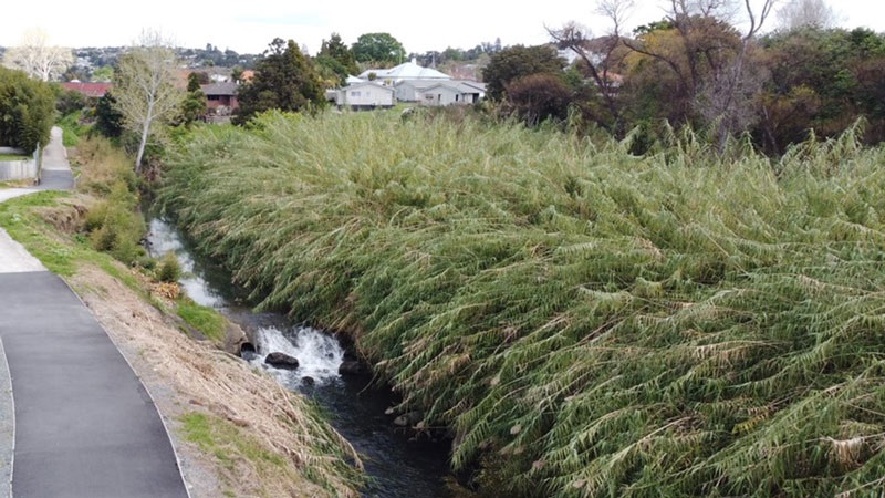
We have been working with ecological services provider Wildland Consultants Ltd to revitalise the Raumanga Stream as part of the Blue Green Network Programme. 

To do this, we are controlling overgrown pest plants before replanting the stream banks with native species and restoring the stream’s riparian ecosystem. 

Leaf litter, small twigs and insects that fall from new native plant species will provide an important food source for microbes and aquatic vertebrate species on which fish feed, and superior shade will help keep water temperatures lower, providing suitable conditions for stream life. 

Since work began in February 2024, substantial progress has been made in the area closer to Otaika Road and the Bernard Street footbridge. Pest plant, giant reed (Arundo donax), has been cleared from the stream banks in this area and replanted with native species, and maintenance will continue to take place until 2017 when the plants are established. 

In 2025, we will be focusing on removing the remaining giant reed from the far side of the shared path, as well as the bamboo (Phyllostachys aurea) along the shared path behind the kura, and other fast-growing exotic species near the bridge. The aim is to have these remaining pest plants controlled before winter, and new natives planted soon after. 

The protection and enhancement of indigenous biodiversity is paramount for Wildlands Consultants Ltd. Machine mulching, manual chainsaw cutting, as well as herbicides are being used to control the infestation. Controlling pest plants by herbicide reduces the risk of erosion, prevents targeted pest plants spreading further, and is effective in reducing the number of repeat treatments required on infestations. 

Agrichemical application will be in low volume, diluted correctly, targeted, and sprayed in a minimal concentration. Protective measures will be undertaken to reduce any environmental risks posed by herbicide use in line with NZS8409:2021. 

The types of agrichemicals that may be used over the entire revitalisation period include:

  • Glyphosate
  • Triclopyr
  • Tetsulfuron
  • Haloxyfop
  • Clopyralid 
  • Organosilicone.

Efforts are being made to keep disruptions to a minimum, however please expect some activity associated with the works between the hours of 7:00am and 5:00pm on weekdays. We will also need to close the Raumanga Shared Path from 3 to 8 March 2025 while heavy machinery is being used, including the possible use of a helicopter.

Read about other recent projects in Raumanga: 

Raumanga Shared Path extension project

Giant reed growing along the northern stream bank on Raumanga Stream.

2. The Upper Hātea Link

The Upper Hātea Link project connects several different pieces of work by the Northland Transportation Alliance, our Parks and Reserves team, private developers, and community groups.

The project proposed to provide a connected and functional recreational route along the Waitaua Stream from Gillingham Road to Whangārei Falls Reserve.

The project includes shared paths / trails, way-finding signage and riparian planting.

3. The Lower Waiarohia Loop

The Lower Waiarohia Loop project proposes to add additional length of shared path to the well-used Hātea Loop beginning from the Kotuitui Whitinga bridge, looping around both sides of the Waiarohia river and across Okara Drive bridge. 

The new shared will be complemented by stormwater upgrades and spaces to relax in that also reflect the rich cultural history of the area.

4. The Waiarohia Recreation Corridor

The Waiarohia Recreation Corridor project focuses on improving ecological and recreational amenity around the Waiarohia Stream flowing through Cafler Park and the sections directly upstream and downstream.

5. The Raumanga Recreation Corridor

The Raumanga Recreation Corridor project seeks to deliver significant Blue - Green outcomes along the Raumanga Shared Path Stage 3 project, notably along the stream between Bernard Street footbridge and Otaika Road.

Raumanga Shared Path Extension

Completed Blue Green programme projects:

Tikipunga - Te Kamo path extension

The Upper Hātea Link project has been extended almost half a kilometre further in time for brisk walks along the stream-side.

The $66,000 Blue - Green Network Programme project was completed by Plantpro Ltd.  It included clearing weeds near Gillingham Road, replacing an old fence with 53 bollards, and installing a 404m long, 2.5m wide shared track from Gillingham Road through the Bush Haven Reserve.

Before and after pictures of the extended shared path.

The path passes a right of way off Daviot Place which was upgraded with new concrete path and steps, and connects to the existing track along the Waitaua Stream.

In coming years, the shared path will stretch a full seven kilometres from the Gillingham Road entrance in Te Kamo to Otuihau, Whangārei Falls, in Tikipunga.

Waitaua Awa Community Planting

Over 200 students and whānau took part in a series of community planting days along the Waitaua Stream in Tikipunga in June 2021 as part of the Blue - Green Network Programme.

Run by Whitebait Connection and Mountains to Sea Conservation Trust and supported by us, the planting days saw over 1,500 riparian native plants get planted along the Waitaua Stream where it flows adjacent to the Totara Parklands Estate subdivision.

A group of people at a community planting day with trees behind them.

Image:  A group of people at a Community Planting day

The plants will improve water quality in the Upper Hātea catchment, and boost amenity along a future walking and cycling trail that will eventually connect Gillingham Road to Whangārei Falls.

Riparian vegetation is a key element of the Blue - Green Programme, which aims to integrate cycling and walking infrastructure with ecological restoration, improved storm-water management, and flood protection.

The planting events coincided with Whangārei Matariki Festival 2021.

Tikipunga Waitaua Bridge

A project to construct a bridge over Waitaua Stream as part of the Tikipunga Shared Path was recently completed in partnership with BridgitNZ.

The new 12-metre long and over 2.5-metre-wide bridge with steel beams and timber cladding replaced a narrow timber board walk with a single rail that was previously in place. 

A picture of the Tikipunga Waitaua Bridge before the improvement project.

Image:  Before the Tikipunga Waitaua Bridge improvement project.

The new bridge provides a safe link for walkers and cyclists to cross the Waitaua Stream, along the Tikipunga Trail - a shared path and cycleway that provides a safe, healthy way for the Tikipunga community to get from Vinegar Hill Road to Whangārei Falls without using roads.

A picture of the Tikipunga Waitaua Bridge after the improvement project.

Image:  After the Tikipunga Waitaua Bridge improvement project.

The programme aims to deliver the outcomes outlined in the Blue / Green Network Strategy adopted in 2016. This is a wide-reaching strategy that will take decades to implement.

Blue / Green Network Strategy

Blue - Green Network Programme July - December 2021(PDF, 25MB)

Programme goals


Goals of the Blue Green Network Programme.