Hātea Loop Shared Path – Huarahi o te Whai

Time to walk: 60 minutes (whole loop)
Distance: 4.2km
Fully accessible
The Hātea Loop – Huarahi o te Whai (Pathway of Opportunity) is accessible for walking, jogging, bicycles, mobility aids, scooters and pushchairs. The entire loop circles the Hātea River.
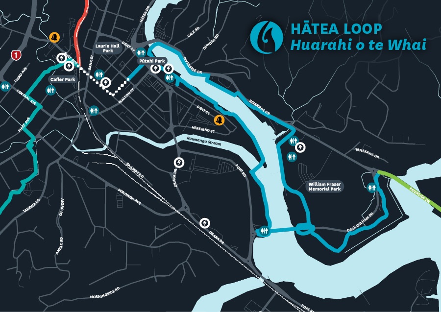
The shared path connects the Town Basin, Te Matau a Pohe, William Fraser Memorial Park, Kotuitui Whitinga, The Canopy Bridge, Claphams National Clock Museum, Town Basin Playground, Reyburn House Art Gallery, a sculpture and heritage trail, Riverbank Theatre, Waka and Wave Millennium sculpture, Pohe Island Bike Park and Riverside Park along the way.
Parking
The Hātea Loop – Huarahi o te Whai can be accessed from a variety of points. There is parking at Town Basin carparks, Bascule carpark and Pohe Island carpark.
What to expect
- An easy, circular, surfaced walk around the Hātea River with spectacular views of the Town Basin marina, two lifting bridges, heritage panels and sculptures.
- Dogs are welcome but must be on a leash at all times.
- Numerous activities, including Camera Obscura, a dog-agility park, family-friendly skatepark, playgrounds, parks and the Pohe Island Bike Park.
- During business hours, there are also a variety of shops and cafes to enjoy.
- You can also borrow a mobility scooter for free from Whangārei Art Museum to get around the Town Basin and the Hātea Loop.

You can view a map of the shared path, which includes the location of activities, sculptures, public toilets, carparks and other facilities.
Hātea Loop Shared Path map(PDF, 167KB)
Preview map
Download the Hātea Loop Shared Path map(PDF, 167KB)
Map legend
 Unpaved path
 Suggested walking link
 Toilets
 Schools
 Locky Docks (secure bike parking)
 Kamo Shared Path
 Connections
 Raumanga Shared Path
 Hātea Loop Huarahi o te Whai
 Onerahi Shared Path
Shared paths are especially made for bicycles, walking, pushchairs, skateboards, mobility scooters, wheelchairs and other similar devices.
Motorbikes, cars and other road vehicles are not permitted on shared paths.
Please keep left when using shared paths, maintain a polite speed and distance while passing others, and stay on the pavement.
Heritage trail
Read more about the historical significance of the heritage trail on the following page.
Town Basin heritage and sculpture trail
Location
Reyburn House Lane, Whangārei 0110 View Map
-35.7265473,174.3287528
Reyburn House Lane ,
Whangārei 0110
Reyburn House Lane ,
Whangārei 0110
Hātea Loop Shared Path – Huarahi o te Whai